After successfully installation the program adds PointCloud command to the Navisworks Navistools ribbon tab. Note that you need separate license to use this module.
This module makes it possible to use laser scanned point cloud files with Naviswork model in a smart way. Point clouds are loaded and unloaded based on your current navigational position. Using this module requires that you already have scanned point cloud files and related model available. To setup a project please read Setup Point Cloud database topic

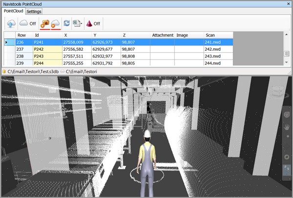
Display a Point Cloud file

To display a point cloud file that is nearest to the navigational position mouse click Display Point Cloud button. Point cloud file is loaded and displayed according current settings set by sliders. When a new point cloud file is loaded to the model then also previous file is automatically unloaded.
PointCloud loading Settings
Program contains 3 slider controls with which you can determine how point clouds are loading.
Focal distance
Controls how far away from your navigational position (from avatars eyes) is the target point that is used when calculating nearest point towards to scan positions. If 0 then it means that target point is same as navigation position.
Inside check radius
Point clouds are not loaded and displayed if they are not inside this radius
PC:s to display
You can set with this slider the number of point clouds to load at once

Dynamic Point Cloud loading
The program can load and unload point cloud files dynamically depending on the Navisworks navigational position. If you turn on Dynamic Point Cloud Loading from the toolbar then the relevant point cloud file is loaded and appended to the Navisworks model if it is inside a predefined volume based on current navigational position. After you have exited from that area, the attached point cloud file will be unloaded and removed and a new one will be appended if it matches the new navigational position.

Launch Image or Point Cloud Design file
Point cloud database contains extra columns for define related image file and point cloud design file for each scan position. If you have filled that information to the database then you can launch them with associated program by using these commands.
Panoramic image file is launched with FSPViewer

Refresh DataViewGrid
You can refresh DataGridView control by using this button. This is needed if you e.g. change active database connection in the DataManager to point to the other database which contains different set of point clouds.

Excel import and export
These functions are for importing and exporting data between database and Excel files. Note that schema of the Excel file had to match database table definitions. More information about using these functions is found at Setup Point Cloud database topic

Scan Position Visualization Cones
You can turn visualization of scan positions on and off with this button. If turned on scan positions are displayed as red cones. You can navigate to any of those scan positions directly by selecting cone with Navisworks select tool.

If you also want to display scan position ids, you can do that by turning Navisworks links on.

There are couple of settings that affects to the scan positions


Visualization Cones Scale Factor
Controls how big visualization cones are. Default value is 0.15 which means that cones bottom radius is 0.15 units
Eye Level Addition
This value is added to the Z-coordinate of the scan position when calculating new camera position. Default value is 0.5 which means that avatars eye level is 0.5 units higher than actual scan position.
Point Cloud Projects
You can add, edit, remove and activate projects by using this form. Project consist of:
-
Name
-
Data Source information
-
Path to the master NWD file
-
Point Cloud folder

Launch Settings
You can define by using this form which program is used to open an image or a point cloud designing file. Form includes buttons to add, edit and delete file associations.
